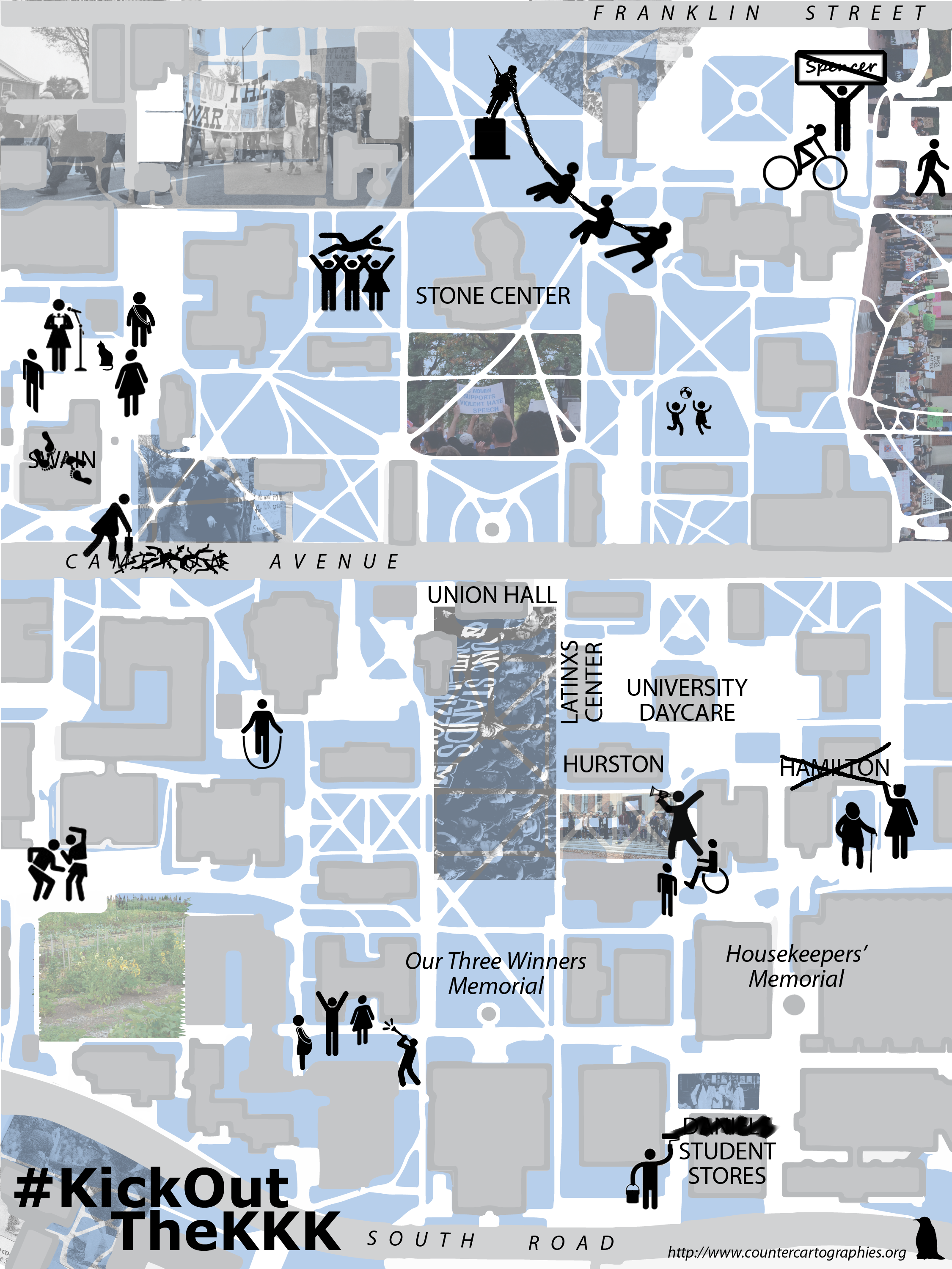
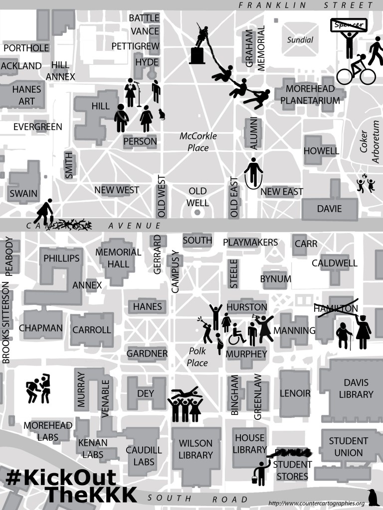
Map in Ruptures, Vol. 1

Since our early days on UNC’s campus, 3Cs has been committed to challenging the memorialization of white supremacy on campus so we were thrilled to be asked to make a map for the zine of the FLOCK (Feminists Liberating Our Collective Knowledge). This is the map we contributed in an attempt to envision past, present, and future struggles on UNC’s campus and imagine the university we want. And check out the whole zine: Ruptures, Vol 1!

Ruptures Map


#KickOutTheKKK

As students at UNC are rallying today to demand the renaming of Saunders Hall (which glorifies William L. Saunders, the Grand Dragon and Founder of the North Carolina KKK) & the contextualization of the “Silent Sam” memorial to Confederate soldiers, we made this map to support their efforts:


hurston hall

For more information about the event today, check out the facebook event

More background:

Video by geography grad students 

“The University of North Carolina’s Silent Sam Statue Represents a Legacy of White Supremacy”

Maribel on Struggles around Precarity

3Cs’ Maribel Casas-Cortés on Against the Grain talking about precarity

From the show’s description:

To many people and activist networks in Europe, “precarity” denotes the insecurity and vulnerability experienced by workers, immigrants, tenants, unemployed people, and others as attacks on labor protections and welfare supports continue. Maribel Casas-Cortés views precarity as a toolbox concept capable of uniting diverse struggles.

And, check out Maribel’s article “A Genealogy of Precarity” here

Mapping police militarization in NC

Recently in response to #Ferguson the New York Times posted a FOIA’ed list of the total amount of military equipment received by US counties from 2006-2014. We put together a quick map of the total amount per capita spent by police agencies in NC counties, and in the full post you can see a full list of what each county bought, from most to least expensive. It might also be interesting to think this map alongside some maps Tim made of NC’s school-to-prison pipeline back in 2013.

Note that this map only represents equipment *given* to counties by DoD, not purchased with their own $ or federal funding. Also, militarization is definitely not the only justice issue with police in NC — for example Durham, a county which doesn’t show up as particularly problematic on this map, has huge disparities in drug searches & arrests between white and Black citizens.


Continue reading

What does a Critical Data Studies look like, and why do we care? Seven points for a critical approach to ‘Big Data’

From co-authors Craig Dalton and Jim Thatcher

How do we approach ‘big data’ critically?  What is to be done with ‘big data’?

There is a need for a critical data studies

As the public discourse around data turns from hubristic claims to existing, empirical results, it’s become nearly as easy to bash ‘big data’ as to hype it (Carr 2014; Marcus and Davis 2014; Harford 2014; Podesta 2014). Geographers are intimately involved with this recent rise of data. Most digital information now contains some spatial component (Hahmann and Burghardt 2013) and geographers are contributing tools (Haklay and Weber 2008), maps (Zook and Poorthius 2014), and methods (Tsou et al. 2014) to the rising tide of quantification. Critiques of ‘big data’ thus far offer keen insight and acerbic wit, but remain piecemeal and disconnected. ‘Big data’s’ successes or failures as a tool are judged (K.N.C. 2014), or it is examined from a specific perspective, such as its role in surveillance (Crampton et al. 2014). Recently, voices in critical geography have raised the call for a systemic approach to data criticisms, a critical data studies (Dalton and Thatcher 2014; Graham 2014; Kitchin 2014). This post presents seven key provocations we see as drivers of a comprehensive critique of the new regimes of data, ‘big’ or not. We focus on why a critical approach is needed, what it may offer, and some idea of what it could look like.

The rest is over at the Society and Space open site (from Environment and Planning D)

critical_data_studies

A Call to Action in Support of the Zapatistas

Join 3Cs in signing the call here and find out about events near you.

SUMMARY OF RECENT EVENTS:

On May 2, 2014, in the Zapatista territory of La Realidad, Chiapas, Mexico, the group CIOAC-Histórica [with the participation of the Green Ecological Party and the National Action Party (PAN)], planned and executed a paramilitary attack on unarmed Zapatista civilians. An autonomous Zapatista school and clinic was destroyed, 15 people were ambushed and injured and Jose Luis Solis Lopez (Galeano), teacher at the Zapatista Little School, was murdered. The mainstream media is falsely reporting this attack on the Zapatistas as an intra-community confrontation, but in fact this attack is the result of a long-term counterinsurgency strategy promoted by the Mexican government.

Given the experience of the 1997 massacre at Acteal, we are concerned about the mounting paramilitary activity against Zapatista bases of support. It is clear that if we do not take action now, the current situation in Chiapas may also lead to an even more tragic end.
Continue reading

Mapping Duke – Class Activity

3Cs was invited to guest lecture/prepare a mapping activity for the Comparative Approaches to Global Issues course at Duke in April. After lecturing about countermapping in general and going over how to use some simple web mapping tools, students were divided into groups to research specific questions about Duke and make their own maps. Read more about the activity we prepared and see pictures below!

Where is Duke? While Duke’s campus may seem to have clearly delimited spatial boundaries, Duke’s influence extends well beyond these limits: Duke’s students and employees live throughout Durham with consequent effects on the urban landscape, students travel, volunteer and study abroad around the world, Duke partners with a wide range of businesses taking part in different commodity chains.

This activity is designed to explore and map out the different practices and institutions that make up Duke and Duke’s connections and effects on its local as well as global surroundings. There are seven themes each addressing a specific aspect of these overarching questions. Each group will be assigned one of these themes and will be responsible for gathering data on their topic by using all or some of the research methodologies described in detail under each theme.
Continue reading

Collective Mapping Workshop at UNC

As part of Radical Rush Week, join 3Cs to collectively map the university. Monday, Sept. 2. 5-7pm in the Pit.

We’ll be constructing a collective counter-map of the university, exploring issues of labor and precarity on campus, the role the university plays in processes of gentrification and wealth extraction, and the university’s relation to flows of information, capital, and people, as well as trying to collectively imagine what other universities are possible.

weekscheduletabloidexperiment

And check out the Radical Rush Disorientation Guide!

Mashing-up Maps: Google Geo Services and the Geography of Ubiquity

A dissertation by Craig Dalton under the direction of Scott Kirsch.

(also available at:  http://gradworks.umi.com/3526116.pdf)

How are Google geo services such as Google Maps and Google Earth shaping ways of seeing the world?  These geographic ways of seeing are part of an influential and problematic geographic discourse.  This discourse reaches hundreds of millions of people, though not all have equal standing.  It empowers many people to make maps on the geoweb, but within the limits of Google’s business strategy.  These qualities, set against the state-centeredness of mapmaking over the last six hundred years, mark the Google geo discourse as something noteworthy, a consumer-centered mapping in a popular geographic discourse.  This dissertation examines the Google geo discourse through its social and technological history, Google’s role in producing and limiting the discourse, and the subjects who make and use these maps.

3Cs presents at Hemi GSI 2012

Liz and Tim gave a talk this Saturday as part of a panel on “Geopolitics of Reimagination: Art, Media, and Social Movements” at the Hemispheric Institute’s 2012 Graduate Student Initiative convergence. See below to click through to the PDF of our presentation, which talked about some of the relationships between mapping and militant research and showed some of our work.

3Cs Presentation at Hemi GSI Convergence Nov 2012